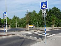
Tag:crossing=marked
| Description |
|---|
| A generic crossing with no traffic-signals of any type, just road markings |
| Group: crossings |
| Used on these elements |
| Useful combination |
| Status: de facto |
| Tools for this tag |
|
This tag describes a pedestrian crossing that is marked but not controlled by traffic lights or people.
The type of marking can still be described explicitly with crossing_ref=*
Another common way to map such crossings is to use crossing=zebra (only if the markings are zebra markings) or crossing=uncontrolled.
How to map
Set a node ![]() on the highway where the transition is and add highway=crossing + crossing=marked.
on the highway where the transition is and add highway=crossing + crossing=marked.
If the crossing is also mapped as a ![]() way, tag it as highway=footway footway=crossing crossing=marked or highway=cycleway cycleway=crossing crossing=marked as appropriate.
way, tag it as highway=footway footway=crossing crossing=marked or highway=cycleway cycleway=crossing crossing=marked as appropriate.
Tags to use in combination
- tactile_paving=yes/no - Indicates whether a blind or visually impaired pedestrian can detect or follow the feature using a cane
- crossing:island=yes/no - Specifies whether a pedestrian crossing has a refuge island
- crossing_ref=* - Used to reference a specific type of crossing markings
- crossing_ref=zebra - A crossing with zebra markings
- bicycle=yes/no - if the crossing is expressly also to be used by cyclists
- lit=yes/no - Indicates whether a feature is lit.
- kerb=* - Used to indicate height and thus accessibility of a kerb
- crossing:markings=* - The existence and style of pedestrian crossing markings
- wheelchair=* - Indicate if a special place can be used with wheelchairs
Software support
Editors
Starting from v2.12.0, released Dec 2018, iD described crossing=zebra as "outdated" and encouraged users to switch to crossing=marked + highway=crossing. This has attracted controversy.
This change was reverted in v2.17.0, released Dec 2019, due to ambiguity issues raised by mappers.[1]
Renderers
OsmAnd draws gray and white stripes along the crossing way and adds a pedestrian pictogram at the crossing node.
Straßenraumkarte Neukölln reserves a parking-free buffer zone around the crossing that is smaller than for crossing=zebra or crossing=traffic_signals. [1]
osm2streets (see AB Street) draws parallel white bars, as opposed to transverse white lines that denote crossing=unmarked.
Routers
OpenSidewalks converts crossing=uncontrolled and crossing=zebra to crossing=marked. [2]
MOTIS Per Pedes Routing indicates whether the crossing is marked [3][4][5] and can calculate a detour that avoids unmarked, unsignalized crossings. [6]
Tagging schemes and tag growth evolution
Graphs of different schemes are shown on the following page link:
📈 http://taghistory.raifer.tech/#***/crossing_ref/zebra&***/crossing/zebra&***/crossing/marked&***/crossing/uncontrolled&***/crossing/traffic_signals
The amount of objects increased exponential after implementation of a iD preset end of 2018 via v2.12.[2]
The growth of the amount of objects stopped immediately after implementation an update of iD preset end of 2022 via id-tagging-schema v5.10, see chart above (green line).[3]
See also
- crossing=uncontrolled - A generic crossing with no traffic signals of any type, just road markings; e.g., zebra-crossings
- crossing=zebra - A zebra crossing
- Proposal: Proposed_features/crossing=marked
