Tag:industrial=shipyard
Jump to navigation
Jump to search
| Description |
|---|
| A place where ships are constructed. |
| Group: landuse |
| Used on these elements |
| Requires |
| Useful combination |
|
| Status: in use |
| Tools for this tag |
|
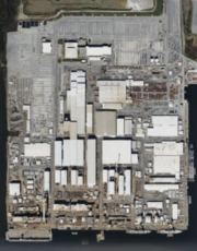
A ![]() Shipyard is a place where ships are built and repaired. Shipyards are fixed facilities with drydocks and fabrication equipment capable of building a ship, defined as watercraft typically suitable or intended for other than personal or recreational use. Activities of shipyards include the construction of ships, their repair, conversion and alteration, the production of prefabricated ship and barge sections, and specialized services, such as ship scaling. Do determine further, use ship:type=*.
Shipyard is a place where ships are built and repaired. Shipyards are fixed facilities with drydocks and fabrication equipment capable of building a ship, defined as watercraft typically suitable or intended for other than personal or recreational use. Activities of shipyards include the construction of ships, their repair, conversion and alteration, the production of prefabricated ship and barge sections, and specialized services, such as ship scaling. Do determine further, use ship:type=*.
How to map
Draw an area ![]() around the grounds of the shipyard or place a node
around the grounds of the shipyard or place a node ![]() at the centre of the grounds.
at the centre of the grounds.
Add
Rendering proposal
Examples
| Photo | Tagging | Note |
|---|---|---|

|
man_made=works landuse=industrial name=Ingalls Shipbuilding operator=Huntington Ingalls Industries start_date=1938 website=https://ingalls.huntingtoningalls.com/ wikidata=Q1193195 wikipedia=en:Ingalls Shipbuilding |
A tagging example |
