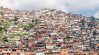
Tag:residential=irregular_settlement
(Redirected from Tag:residential=slum)
Jump to navigation
Jump to search
| Description |
|---|
| Used with landuse=residential to further refine the residential area. |
| Group: landuse |
| Used on these elements |
| Useful combination |
|
| See also |
| Status: in use |
| Tools for this tag |
|
Undocumented Tag
This page was created because the tag is in use but not documented. You can help OpenStreetMap by expanding it!
Please keep in mind that there could be similar tags and / or that this tag might be deprecated.
Always be careful when using undocumented tags!
This page was created because the tag is in use but not documented. You can help OpenStreetMap by expanding it!
Please keep in mind that there could be similar tags and / or that this tag might be deprecated.
Always be careful when using undocumented tags!
This tag is used together with landuse=residential, to further refine the residential=* key.
Very dense residential areas or settlements (in inner city, urban, peri-urban, or suburban areas), displaying characteristics such as crowding (or overcrowding) and compact, or sub-standard housing units. The residential area are often traversed by a network of foot paths or narrow roads, with inadequate or informal delivery of utilities; reflecting a precarious or informal state of occupation reliant on (political) dependency on local authorities
