Tag:service=drive-through
| Description |
|---|
| A drive-through way where customers can visit a business without leaving their cars. |
| Rendering in OSM Carto |

|
| Group: properties |
| Used on these elements |
| Requires |
| Useful combination |
| Status: de facto |
| Tools for this tag |
|
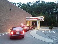
Use service=drive-through with highway=service to indicate that a highway is for ![]() drive-through service where customers can visit a business without leaving their cars.
drive-through service where customers can visit a business without leaving their cars.
In the United States, there are three common amenities which may be associated with drive-throughs: amenity=pharmacy, amenity=bank, amenity=fast_food. Other amenities that may have drive-throughs include amenity=library, amenity=atm, and shop=alcohol. Quite common in Italy is a drive_through lane or service lane at gasoline stations where an attendant fills up the car, payment at the driver side window at a significant mark-up per litre, 15-20 Euro cents is common i.e. amenity=fuel,
Usage
Use with
Drive-throughs are typically oneway=yes.
A drive-through can be mapped going through a car wash (building=retail amenity=car_wash); the indoor portion should be tagged tunnel=building_passage.
If a drive-through passes under an awning or a roof with a wall on only one side, tunnel=building_passage should not be used. Instead, use covered=yes.
See also
- drive_through=yes/no – tagged on the amenity that may offer drive-through service
- barrier=height_restrictor – a drive-through may have a height restrictor ahead of an overhang roof at the pick-up window
