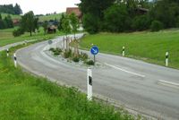
Tag:traffic_calming=island
| Description |
|---|
| A traffic calming island is a structure for the purpose of slowing down traffic, temporarily separating two different traffic directions. |
| Group: highways |
| Used on these elements |
| See also |
| Status: de facto |
| Tools for this tag |
|
A traffic calming island is a structure for the purpose of slowing down traffic, separating at least two lanes of a highway for a short distance[1]. The width of the island is usually under a few meters. The island doesn't necessarily have to have a right-of-way indicator. The area of the island itself can be drawn using area:highway=traffic_island, but the traffic calming feature is meant to be used as a point on the way itself, or tagged on part of the way.
Note that as of mid April 2023, only about 3% of pedestrian crossings with pedestrian refuges (crossing:island=yes or the deprecated crossing=island) are also tagged with traffic_calming=island. So as a data consumer, if you are looking for all traffic islands, you should look for crossings with the tags mentioned, too.
How to map
For an island between two lanes of a carriageway, either:
- put a
 traffic_calming=island node on the road (especially if it's a small island),
 - split the carriageway into parallel lanes, marked oneway=yes as appropriate, add the traffic_calming=island to the ways, and optionally draw the island itself as an area
 between them using area:highway=traffic_island.
Tags to use in combination
For traffic calming islands drawn as a node ![]() :
:
- direction=* - if an island is made to only slow down traffic in one direction
For traffic islands drawn as an area ![]() using area:highway=traffic_island:
using area:highway=traffic_island:
- surface=* – Surface of the traffic island, e.g. asphalt, paving_stones
- landuse=grass – For traffic islands covered with grass (other landuse=* or natural=* types may also occur, e.g. landuse=greenery or natural=shrubbery)
- barrier=kerb + kerb=* – For solid traffic islands
Rendering
- One possible rendering may be as a small hollow dot in the middle of a node, or a small hollow line in the middle of a way. When creating software, these choices are yours.
- None, currently, by the osm-carto layer.
- iD and JOSM editors represents this tag with an icon: Example-object
- OsmAnd has a possibility to alert drivers of incoming traffic_calming=* features, a warning icon with a speed bump is shown[2].
Possible tagging errors
See also
- crossing:island=* – Specifies whether a footway=traffic_island crossing has a refuge island
- highway=mini_roundabout – A road junction where the traffic goes around a painted circle or traversable island and has right of way.
- traffic_calming=painted_island – An island painted on a road
- Proposals:
- area:highway=traffic_island is mentioned in a 2011 inactive proposal.
- The proposal landuse=traffic_island for a pedestrian refuge on roads was abandoned.
Weblinks
- Traffic island on Wikipedia
References
- ↑ It's not clear yet if this tag is to be used for solid and/or painted islands. As has been pointed out here (Proposed_features/Road_divider_areas, Feb 2022) and here (What’s the traffic_calming=island area?, Feb 2023).
- ↑ OsmAnd Docs - Alert types -https://osmand.net/docs/user/widgets/nav-widgets/#alert-types
