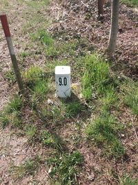
Tag:waterway=milestone
Jump to navigation
Jump to search
| Description |
|---|
| A landmark of stone or metal to indicate the distance traveled along a watercourse. |
| Group: waterways |
| Used on these elements |
| Useful combination |
| See also |
| Status: de facto |
| Tools for this tag |
|
Used for a distance marker along a waterway. The signs/markers with the river kilometres can be found left or right on the shore.
How to map
For the pole/board/marker stone on the shore
Draw a node ![]() and add the following:
and add the following:
- waterway=milestone
- distance=* or river:waterway_distance=* – specified distance (in km); distance=* is used much more frequently (approx. 10:1)
Optional seamark tags:
- seamark:distance_mark:category=pole/board/unknown_shape
- seamark:type=distance_mark – OpenSeaMap/Distance_Marks
- seamark:distance_mark:distance=number
- seamark:distance_mark:units=kilometres/hectometres
For the virtual kilometre point in the river
Place a point ![]() directly on the way
directly on the way ![]() that represents the waterway and add the following:
that represents the waterway and add the following:
- waterway=milestone
- distance=* or river:waterway_distance=* – distance (in km); distance=* is used much more frequently (approx. 10:1)
Optional seamark tags:
- seamark:distance_mark:category=not_installed – virtual river kilometre
- seamark:type=distance_mark – OpenSeaMap/Distance_Marks
- seamark:distance_mark:distance=number
- seamark:distance_mark:units=kilometres
Rendering on OpenSeaMap
The black circles are the milestones or the hectometre stone (hm1), the coloured circles are the virtual kilometre points.
See also
- river:waterway_distance=* – An object's position along a waterway. The distance is measured from the spring.
- A more detailed system for navigational use is defined in the Openseamap: OpenSeaMap/Distance_Marks
- seamark:type=distance_mark
- seamark:distance_mark:distance=number
- seamark:distance_mark:units=kilometres
Similar tags
For “modern” milestones:
For “historic” milestones:


