Talk:MapRoulette/Challenges
Lather, Rinse, Repeat
Surely every past challenge has to be repeated periodically. What's the current count of each previous challenge? Brycenesbitt (talk) 21:41, 17 March 2014 (UTC)
Untagged ways
Untagged ways that are not members of a relation are typically an error of some kind.
From checks, they most commonly arise in 3 ways
- Traced objects that were not tagged when they were traced
- Mistakes in tracing (generally short 2-3 node ways that don't correspond to anything physical)
- Objects still being uploaded where the multipolygon has not yet arrived.
The desired resolution for 1 is to add appropriate tagging if it can be determined from the imagery.
The desired resolution for 2 is to delete.
The desired resolution for 3 is to do nothing and not detect them.
Local knowledge helps for adding appropriate tagging but in many cases it is obvious what was traced (e.g. a building)
These are machine detectable from a pgsnapshot database. The following SQL is a modified version of what I used to find them locally.
SELECT ways.id as id, version,
(SELECT users.name FROM users WHERE users.id=ways.user_id) as user, tstamp
FROM ways LEFT JOIN relation_members AS parents
ON ways.id = parents.member_id AND parents.member_type='W'
WHERE parents.member_id IS NULL
AND tags=hstore('')
AND tstamp < TIMESTAMP 'now' - INTERVAL '1 day';
- Sounds like a great MR challenge to me! How about untagged nodes? Those are generally less meaningful but could be a sign (at least in the United States) of ways deleted by the redaction. Martijn van Exel (talk) 21:40, 11 December 2013 (UTC)
- Current count is 251565 on a worldwide database based on the query above. Martijn van Exel (talk) 21:44, 11 December 2013 (UTC)
No-Name-A-Tron
This is similar to the above untagged ways challenge and may be redundant. This one focuses on reviewing unnamed streets. As such it might make more sense to do the no tag challenge first and then follow it up with the no name challenge. I think it would be helpful to focus on the higher classification streets first (Motorway, Urban Primary, Urban Secondary, ect) and work your way down from that due to the large number of unnamed private streets and tracks within the US. The basic idea is to get the street naming as accurate as possible as it forms the base of OSM. It would be great if there was someway to automate the creation of the 2012 TIGER TMS tile service within JOSM for this challenge so that it launches when you choose "Edit with JOSM." Here is the link to the 2012 TIGER tile service. http://wiki.openstreetmap.org/wiki/TIGER_2012 --T 9er 13:47, 3 December 2012 (UTC)
- I guess this one is more specific than the untagged ways one, and I believe is useful in its own right. Martijn van Exel (talk) 21:43, 11 December 2013 (UTC)
Tiger-Tweak-A-Tron
Building off your work with the Tiger Deserts, have mappers review and update any old tigerline data that hasn't been touched since it was uploaded. You could focus on urban areas and major roads first and then work your way to rural minor roads. The emphasis would be on whole ways that have been untouched instead of just nodes although you could do it either way.
- I believe this has been covered since in the Battle grid as well as in the TIGER overlay that Eric Fischer did. Martijn van Exel (talk) 21:46, 11 December 2013 (UTC)
Block-A-Tron
Use 2000 and 2010 census blocks to find areas of growth and then compare the osm street length to the 2012 tigerline street length. Have mappers review and map blocks where there is growth in population and more 2012 tigerline street data than osm. If this is too much you could just compare the street lengths and leave out the demographic comparison due to the changes in block size and shape from census to census. I found when using the re-map-a-tron if I encountered an area with missing or messy roads I went ahead and updated the whole area so it might not be too much of a stretch to think mappers would update a one block at a time. --T 9er 13:47, 3 December 2012 (UTC)
- This too seems to have been adequately covered with the battle grid. Martijn van Exel (talk) 21:49, 11 December 2013 (UTC)
Keep-Right-A-Tron
Status: In Progress I was wondering if you could use the work from the KeepRight website for the next challenge. I'm thinking "almost-junctions" and "floating islands" would be two good places to start.
- Yes great point. We can either pull directly from keepright (I have contacted with the author) or replicate the scripts in the MapRoulette environment. Martijn van Exel (talk) 21:52, 11 December 2013 (UTC)
Cracked areas
Take a look at the two areas here: http://osm.org/go/0E6JSxZAw-- That's 180625454 and 180625453. At first, they look contiguous. But in fact, there are micro-cracks -- two nodes used by each area aren't used by the other.
Disconnected platforms
Railway platforms that aren't connected to the rest of the graph. Sometimes these will require local knowledge, but sometimes the satellite image will be good enough. http://www.openstreetmap.org/browse/way/109969548
landuse:grass ways that cross roads
http://www.openstreetmap.org/?lat=51.6646268963814&lon=4.09560710191727&zoom=18
Detecting traffic signals on major intersections
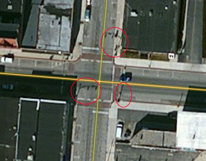
Intersections of tertiary and higher (except _links) are quite likely to be controlled by traffic signals. Take this one here:
(map)
In JOSM, the Bing imagery clearly shows (the shadows of) traffic signals, and the tag can quickly be added to the intersection node:
- This is only 'quite likely' in urban areas, and I'd drop tertiaries outside downtowns. --NE2 19:46, 12 November 2012 (UTC)
Railway crossings
Keep right doesn't have a check for railways that cross roads without nodes. I'd recommend the following:
- railway=rail only, without service=*
- highway=secondary and up (including links)
- no bridge=* or tunnel=* tag on either way (unless it's *=no)
- no intersection node, or intersection node without a railway=level_crossing
Of course these are sometimes bridges and sometimes level crossings. On major roads the imagery is almost always good enough to know which it is. The instructions should note that mappers should be careful about marking a railway as abandoned, since railway ways are often long and may only be partially abandoned. --NE2 15:55, 2 November 2012 (UTC)
Follow the Dots (of deleted ways)
Recently, while working on Martijn's current Mapathon, I found a 10-mile-long secondary road that had been removed in the redaction and had not been caught or repaired in subsequent Mapathon efforts. However, the dots that indicated a deletion remained. Therefore, one way to make sure we restore those ways could be to search for remaining dots on the map. Though this one was long, most that I still encounter are short (like a block or so), so they should be easy fixes.
+1 on this. I've found them also... or... just the empty nodes. Brycenesbitt (talk) 21:11, 17 March 2014 (UTC)
These might be difficult to detect by a non-human, any ideas? Martijn van Exel 17:31, 11 November 2012 (UTC)
Too-long bridges
For example: http://www.openstreetmap.org/browse/way/178908572
These are usually from TIGER, but may be human error. One way to detect them is to look for intersecting non-bridge ways, or simply to look at the length and suck up the false positives. --NE2 00:11, 3 November 2012 (UTC)
Node -> Area GNIS imported nodes
In the U.S. there's imported GNIS data, seemingly for every hospital, school, church, lake, park, cemetery, and various other things. A lot of these things would be better represented as areas. It's not always the case e.g. some churches are quite small, and someone doing normal mapping might decide to stick it in as a node, but for many of those other things, we'd like mappers to convert the node into an area. ![]() ->
-> ![]() . I do quite a lot of this using JOSM and the 'Paste tags' command. Not sure if it's so easy to do this in Potlatch.
. I do quite a lot of this using JOSM and the 'Paste tags' command. Not sure if it's so easy to do this in Potlatch.
-- Harry Wood 15:58, 13 November 2012 (UTC)
- This requires some local knowledge due to the large number of GNIS errors (they got the data by going through a phone book and geocoding the addresses). --NE2 17:23, 13 November 2012 (UTC)
- How about merging GNIS nodes with similarly-named areas nearby? Mappers – and not just newbies – often overlook the GNIS nodes when mapping parks and stuff, because they're mostly nondescript green dots in Potlatch. Unfortunately, Potlatch only supports pasting tags from way to way and from node to node at the moment. – Minh Nguyễn (talk, contribs) 07:17, 14 November 2012 (UTC)
Oh I just realised there's a page USGS GNIS and even a section USGS GNIS#Converting GNIS Nodes to Areas. Nice. -- Harry Wood 11:35, 16 November 2012 (UTC)
Just as common: the area is already present, but needs to be merged with the GNIS node, hopefully preserving the important gnis (or gns) ID number. Brycenesbitt (talk) 21:40, 17 March 2014 (UTC)
highways and waterways intersect
I've noticed a lot of highways and waterways intersecting and the bridge tag for the highway had not yet been added. A SQL query of intersections of these shouldn't be too hard.
- There are going to be way too many of these where it's not obvious from aerials: http://keepright.at/report_map.php?zoom=9&lat=36&lon=-79&layers=B0T&ch=0%2C192&show_ign=1&show_tmpign=1 --NE2 08:45, 28 November 2012 (UTC)
- What about for cases where a waterway and highway are improperly connected? That is, they're connected by a node but without a highway=ford or ford=yes tag. There was a user that did this a huge number of times in my region, and I've fixed as many as I could find, but it's hard to detect with the current tools.--Alester (talk) 23:36, 18 March 2014 (UTC)
POIs without Addresses
We have many POIs (restaurants, shops, etc.) which have a name, but do not have an address. We should find the types of POIs that would qualify for having an address and present them to the user. In addition, some of these POIs may also have a website. --Emacsen (talk) 17:20, 23 February 2013 (UTC)
Unclosed Areas
Some areas ways (buildings, lakes, etc.) are unclosed and would be easy to fix.--Emacsen (talk) 17:20, 23 February 2013 (UTC)
Invalid Relations
Many relations in OSM are invalid, for example, multipolygons with no outer ways. Relations of this type should be identified and offered for fixing.----
Power Lines That Intersect with Roads
Where power lines cross roads, some mappers have made them intersect. Of course, this does not happen in reality. This should be an easy one to correct, as it is easy to see. This is a corollary to highways intersecting with waterways. I think it should be possible to detect both of these. Waterways and power lines have some legitimate intersections, but a significant number of the intersections are with highways.
Link Roads Mismatch
Link roads should match the highest classification of the road that they connect to. For example, a secondary_link road should have at least one connection to a secondary (or secondary_link) road, and no connections to primary, trunk, or motorway. The mismatch often occurs when someone changes the classification of the main road, but does not change the connecting link roads to match.
To fix these, change the classification of the link road to match the highest classification of roads it connects to.
Here is some SQL that finds mismatched link roads (using the Osm2pgsql schema):
CREATE TABLE highway_rank
(
  highway TEXT,
  rank INTEGER
);

INSERT INTO highway_rank VALUES ('motorway', 1);
INSERT INTO highway_rank VALUES ('motorway_link', 1);
INSERT INTO highway_rank VALUES ('trunk', 2);
INSERT INTO highway_rank VALUES ('trunk_link', 2);
INSERT INTO highway_rank VALUES ('primary', 3);
INSERT INTO highway_rank VALUES ('primary_link', 3);
INSERT INTO highway_rank VALUES ('secondary', 4);
INSERT INTO highway_rank VALUES ('secondary_link', 4);
INSERT INTO highway_rank VALUES ('tertiary', 5);
INSERT INTO highway_rank VALUES ('tertiary_link', 5);

SELECT * FROM (
  SELECT link_roads.osm_id AS link_osm_id,
    link_roads.highway AS link_type,
    link_roads_rank.rank AS link_rank,
    MIN(all_lines_rank.rank) AS connect_to_rank
  FROM planet_osm_line AS link_roads
  INNER JOIN planet_osm_line AS all_lines
  ON ST_Intersects(all_lines.way, ST_StartPoint(link_roads.way)) OR
    ST_Intersects(all_lines.way, ST_EndPoint(link_roads.way))
  INNER JOIN highway_rank AS link_roads_rank
  ON link_roads.highway = link_roads_rank.highway
  INNER JOIN highway_rank as all_lines_rank
  ON all_lines.highway = all_lines_rank.highway
  WHERE
    all_lines.osm_id > 0 AND
    all_lines.osm_id <> link_roads.osm_id AND
    (link_roads.highway='teriary_link' OR
     link_roads.highway='secondary_link' OR
     link_roads.highway='primary_link' OR
     link_roads.highway='trunk_link' OR
     link_roads.highway='motorway_link')
  GROUP BY link_roads.osm_id, link_roads.highway, link_roads_rank.rank
)
AS link_roads_connect
WHERE link_roads_connect.link_rank <> link_roads_connect.connect_to_rank;
Lonely Buildings
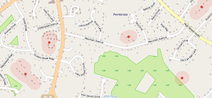
With the recent building imports, it's easy to spot missing residential streets, service roads and long driveways. Most of these streets are visible on aerial imagery (such as Bing), making tracing and adding them an easy task. Though often less accurately drawn, Tiger2012 has some of them and this can be a source of street names. Where street names are not available, map notes can be used to indicate that a ground survey is needed.
PostGIS scripts for finding lonely buildings at github.com/Ahlzen/lonely_buildings
In the above example, red markers (and surrounding red areas) highlight clusters of "lonely" buildings with no road nearby.
--Ahlzen (talk) 19:27, 27 June 2013 (UTC)
Turning circles incorrectly tagged as roundabouts
Apparently some people have been mis-tagging what should be a highway=turning_circle as a roundabout or mini_roundabout. It would be relatively easy to do a query for these that appear at the end of a way that are not connected to another way. Some should just be retagged as highway=turning_circle, but some (if there is a tree or other obstruction in the middle, should actually be drawn as a 'loop' or 'teardrop' at the end of the way. -AndrewBuck (talk)
Oversized tennis courts
Almost all tennis courts are part of a larger complex of courts, rarely is there just a single court built. Some mappers will mark this entire large area as a single giant tennis court. A more accurate representation of reality is to mark a barrier=fence around the larger area and then draw a separate tennis court for each actual court. These oversized ones will be easy to spot with a DB query by simply sorting by area. Anything larger than a standard tennis court size by more tha 20% or so is a likely candidate for splitting up as described. -AndrewBuck (talk)
- or make no fence arround, but leisure=sport_centre. --Zuse (talk) 09:47, 2 April 2014 (UTC)
Playground details
Currently we have thousands of areas mapped and tagged leisure=playground, but this is just the outline of the area. It would also be good to add details about the swingsets, jungle gyms, etc internal to the playground. These get added as nodes with the playground=* tag to describe what kind of equipment they are. This would allow people to search for a playground with only certain features at it (show only playgrounds with at least a swingset and a sandpit for example). The items are pretty easily identifiable in aerial imagery so it should be possible to do a challenge for them. -AndrewBuck (talk)
- I did not see bing aerial imagery which allows anything else than maybe to recognize a sandpit. So that proposal sounds like a suggestion to do wild guesses in an armchair ... --Aseerel4c26 (talk) 00:34, 26 July 2013 (UTC)
Addresses with postal codes but without city and/or address
This is applicable to the whole world, not just the U.S.
Many people do not add the city to their addresses because they consider it implied by the fact the node/way is within the administrative boundary of that city. This doesn't make sense when gathering data by a certain tag, such as postal code. All addresses should contain the city and the street in order to be usable independently. These are automatically identifiable from the database.--Strainu (talk) 12:18, 19 November 2013 (UTC)
- If they can be derived from the database, what do we need MapRoulette for? Martijn van Exel (talk) 19:19, 17 December 2013 (UTC)
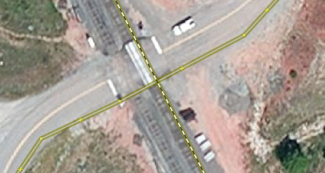
Railroads intersecting with highways without crossing
Common in the U.S. where railroad and street data was imported from TIGER. Railroads and highways intersect without a shared node and without railway=crossing.
First stab at a query for these (pretty slow and needs optimization):
with rail as (select * from ways where tags->'railway' = 'rail')
select ways.id from ways, rail where ways.tags?'highway'
and not st_intersection(ways.linestring, rail.linestring) &&
(select geom from nodes where tags->'railroad' = 'crossing');
Martijn van Exel (talk) 18:36, 17 December 2013 (UTC)
Dangling way
I encountered a couple cases during Battle Grid editing where an editor did not complete editing. The incomplete edit includes a way that does not connect to another like it is supposed to. A couple images as an example:
KristenK (talk) 02:21, 19 December 2013 (UTC)
Overlapping way, at Intersection
I have also encountered ways that cross and are supposed to represent an intersection, but do not share a node that would represent the intersection
KristenK (talk) 02:21, 19 December 2013 (UTC)
Correcting Dual Carriageways
There are many ways in the dataset that have a FIXME=dual carriageway tag key/value pair. Some have been addressed, others haven't.
KristenK (talk) 02:21, 19 December 2013 (UTC)
Power line intersections highway =
Common in the tiger dataset. Brycenesbitt (talk) 18:11, 20 March 2014 (UTC)
Website tag does not match node/way
Monitoring a website tag is an excellent way to discover changes to local business and attraction nodes. KeepRight has just such a check: it loads the web page and looks for keyword matches. By example "Blake Memorial Gardens" would need to have at least two of those keywords on the landing page it flags. Of the ones I've processed in KeepRight perhaps half are false alarms, but he other half are typically businesses no longer in operation. On occasional I find spam. Brycenesbitt (talk) 21:38, 17 March 2014 (UTC)
Duplicate Addresses
A user in the German forum suggested a duplicate addresses challenge. My housenumbervalidator shows, among other problems, duplicate addresses.


