Talk:MassDOT
Jump to navigation
Jump to search
Merging with existing data
# Download all nodes in bounding box of MBTA bus stop data:
wget 'http://open.mapquestapi.com/xapi/api/0.6/node[highway=bus_stop][bbox=-71.3,42.10,-70.8,42.59]' -O osm_bus_stops.osm.xml

# Find users who've last touched these nodes
sed -e '/user/ !d' -e 's/^.*user="\([^"]*\)".* .*/\1/' osm_bus_stops.osm.xml | sort | uniq
123 nodes, only a handful with shelter/bus/wheelchair tags. List of users:
Ahlzen
BruceAHz
fiveisalive
fuzzyjoel
JasonWoof
JGorton
jnpato
Lilys
marinero
mblackwell
morganwahl
NE2
OceanVortex
Paul Knight
pratyk
sejohnson
ShankarV
spaceeinstein
stannenb
Trex2001
ulfl
wambag
wheelmap_visitor
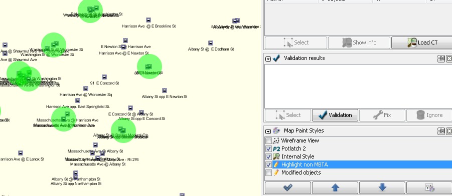
These can be fairly quickly merged in JOSM, using the merge tool "m". Also, try an additional MapCSS style to highlight original OSM nodes like this:
meta
{
    title: "Highlight non-MBTA bus_stops";
    description: "ighlight non-MBTA bus_stops";
    version: "0.1_2011-08-12";
    author: "Josh Doe";

    watch-modified: true;
}

node[highway=bus_stop][source!=massdot_import_081211]::modified_layer
{
    symbol-shape: circle;
    symbol-size: 50;
    symbol-fill-color: lime;
    symbol-fill-opacity: 0.5;
    z-index: 20;
}
This style gives you something like this:
Just open the two OSM.XML files, merge layers, then look for all the green circles, selecting it and the adjacent MBTA bus stop, merging with 'm, and reconciling the differences. If you overwrite source=* with the new source (massdot_import_081211), then the green circle will go away and you can continue until there's no more green. :) -- Joshdoe 20:16, 12 August 2011 (BST)
