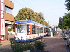
Trams

|
| Description |
| A form of public transport |
| Tags |
Differences to other railways
Trams are distinguished from other rail-based public transport systems in that, for at least some of their route, they travel along the road, rather than on a separate rail corridor. Where the tracks are embedded within the road, the trams may share the space with other road traffic, such as private motor vehicles, or perhaps buses and taxis only. Sometimes, for instance on wide roads, trams may have their own tracks on which only they can travel, separated from the main road traffic by a small island (in a similar way to some cycle paths). In other circumstances, road traffic and trams may share the same space, but different restrictions (turns, one-way, etc) may apply.
Tram tracks
Tram tracks are tagged with railway=tram.
Frequently there are two tracks, one track in each direction, running parallel to each other. It is now recommended to draw each track separately. In the past, two tracks were often mapped as as a single line representing both tracks with tracks=2. This tagging style is now discouraged.
Tram tracks are sometimes physically embedded within the highway, and sometimes completely separate.
Embedded tracks
Tram tracks integrated within an highway, where other traffic is allowed to share the same space.
Latest trend in mapping embedded tracks is to separate geometry of tram tracks and highways entirely. Highway is mapped by a way highway=* with its tags and each single track is mapped as a railway=tram according to its real position. Some of the advantages of this are precision, intuitivity, editing ease, less tags on all the ways. See this section of the Karlsruhe, Germany map for a well-mapped area including trams. If using separate ways, add embedded_rails=* to the road way.
In the past some mappers have drawn a new way for the tram tracks but reuse the nodes as the street where they run completely parallel. This has the drawback that ways are harder to select in visual editors. To draw the railway on top of the street but using its own nodes suffers from the same issue.
A different method, which is used is to draw a single way with both the highway=* and railway=* set at the same time contradicts the One feature, one OSM element principle. That principle has significant exceptions, however, and mapping them as separate ways contradicts the principle that separate ways should be physically separate.
Separate tracks
Where tram tracks separate the road into two carriageways (one for each direction), the road is usually mapped as two ways with oneway=yes, and each tram tracks is mapped as separate way in the middle.
Where tram tracks run to the left or right of the road, each track is usually drawn as a separate way on the appropriate side.
Tram stops
Tram stops are mapped as a node attached to the track, tagged with railway=tram_stop. A tram stop is a place where a passenger can embark/disembark a tram. It generally comprises a sign, maybe with a small shelter, timetable and facilities for unattended ticket sales (vending machines). There are no operating staff present.
Platforms, where passengers await and board the coaches can be tagged as a node or area with the tags railway=platform (more common, original tagging) and/or public_transport=platform (less common).
The location on the tracks where the tram stops is marked by a single node with the tags railway=tram_stop. Some mappers also add public_transport=stop_position and tram=yes.
Tram service routes
- Main article: Public transport#Service routes
Tram systems by country
- Finland
- Poland
- Slovakia
- Switzerland
- United Kingdom
- United States
- United States/Railways may be considered an entry point to describe all rail (passenger AND freight) in the USA. However the trend has been to divide up this large task to each of the 50 states in a state-level /Railroads wiki. If such a wiki exists for a given state (all Western states have at least a skeletal wiki, some Eastern states do, too), these have a Level 1 "Passenger trains" section, with further subsections: a Level 2 subsection (often passenger=urban or passenger=local) should describe trams in that particular state. For example, Texas/Railroads#Urban and local_trains.
| ||||||||||||||||||||||||||||||||||||||||||||||