uMap/Guide/Import data files
Jump to navigation
Jump to search
This article show how map information can be imported in a uMap map.
Options and result depend heavily on the source format.
Recipe:
- Start edit by
- Select on the right side Import data ![]() or
or Ctrl-I
Sources of data
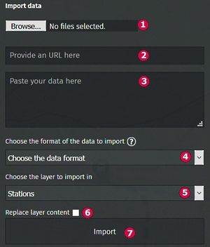
- Data can be read from file. See field 1
- Data can be found by URL. See field 2.
- Or paste the text of the data directly in field 3.
Data format
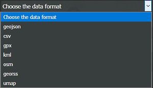
The format is derived from the extension of the file. If this is not possible a format can be set with drop-down list at 4. The list below shows details. A bold format can be exported by uMap:
- geojson: JSON-data according to geographic scheme GeoJSON (*.json / *.geojson). All properties will be imported.
- csv: Comma, tab or semicolon separated list, SRS WGS84 is assumed. (*.csv). Only points will be imported. Import checks headingnames with prefix lat or lon. All other columns will be imported as properties.
- gpx: XML coded data according to geographic scheme GPX (*.gpx). Imported properties: name, desc.
- kml: XML coded data according to geographic scheme KML of Google Earth (*.kml). Imported properties: name, description.
- osm: XML coded data according to geographic scheme OpenStreetMap (*.osm)
- georss: XML coded data according to geographic scheme GeoRSS (*.georss)
- umap: Data exported by uMap (*.umap) (starting uMap v.0.8). Everything is imported: map information, layer information and geometry.
Import destination
The dropdown menu (5) selects the destination of the imported data. Options are an existing layer or a new layer by Import in new layer.
Existing geometry in a layer can be overwritten by 6: Replace layer content.
|
The umap format contains map and layer information. Effects : |
Import
Start the import action by click on button 6.
Save

