Uk:Tag:allotments=plot
| Опис |
|---|
| Окрема виділена ділянка в межах садівничого товариства |
| Група: landuse |
| Застосовується до цих елементів |
| Мається на увазі |
| Використовується разом з |
|
| Статус: затверджений |
| Інструменти |
Використання
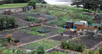
Теґ allotments=plot використовують щоб розмежувати ділянки на території садівничого товариства. Зазвичай територія садівничого товариства розділена на безліч таких ділянок.
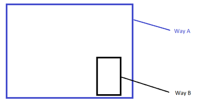
Додайте ділянку ![]() усередину території
усередину території ![]() з теґом landuse=allotments.
з теґом landuse=allotments.
Лінія A = landuse=allotments
Лінія B = allotments=plot
Identifying Plots
You may use the ref=* to identify the plot. Plot identifiers are typically numeric (1, 2, 3,...), alphabetic (A, B, C,...), a grid designation (A1, A2,... B1, B2,...), or similar. The reference is not rendered at present but this is in the process of being implemented. It is possible that name=* will also be rendered.
Warning: Hand-drawn maps maintained by allotment associations may include the names of people operating the plots. If you have access to such a map you should not include the name of any living person in a plot reference or name as this might contravene data protection/privacy legislation. Even if the country where the plot is located has no such legislation now, it may in the future. There are also concerns that some countries may have legislation on these matters that is so strict that identifying the operator of the plot in another country may lead to them blocking access to OSM.
Note: You should not insert the names of people in a "hidden" way by using description=*, note=* or any other tag. Those tags may not be rendered but they are easily accessible using, for example, the query tool of the standard map which will show all tags associated with an object.
See also
- Proposed features/Tag:allotments=plot - discussion and voting for extension of values.

