User talk:Bayubudi i
SKENARIO BANJIR RT 01/RW16 KEL. SURAU GADANG, KEC. NANGGALO, KOTA PADANG
NAMA
Bayu Budi Irawan
Username OSM: Bayubudi_i
LOKASI PEMETAAN
Lokasi pemetaan berada pada RT 01/RW 16 Kelurahan Surau Gadang, Kecamatan Nanggalo, Kota Padang.
Lokasi ini merupakan sebahagian kecil dari komplek Perumahan yang di kawasan Siteba,
dimana lokasi ini sering terjadi Banjir Genangan jika terjadi hujan ringan.
Adapun banjir genangan yang terdapat pada lokasi tersebut mempunyai ketinggian antara 30-50 cm,
sehingga cukup mengganggu aktivitas masyarakat.
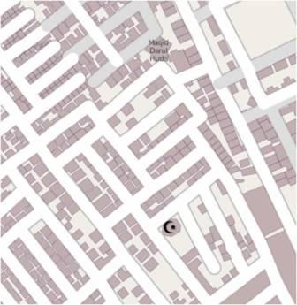
Hal ini dikarenakan pada sistem drainase pada lokasi ini tersumbat, Berikut ini ditampilkan kondisi eksisting dengan gambar citra satelit.
METODOLOGI PENGUMPULAN DATA
Sebelum melakukan survey ke lapangan dilakukan persiapan yaitu melakukan identifikasi lokasi dan pembuatan kuisioner survey yang memuat atribut yang diharapkan termasuk Jalan dan Bangunan serta fasilitas umum lainnya. Selanjutnya dilakukan pengambilan data dilakukan pada hari Rabu, 3 April 2013.
Pengambilan data ke lapangan dilakukan dengan menggunakan Walking Paper untuk area yang akan dipetakan.
HASIL PEMETAAN
Secara umum kondisi eksisting pada lokasi ini telah dipetakan dan hanya terdapat sedikit penambahan/pengurangan.
Namun yang berbeda adalah informasi mengenai objek peta tersebut dimana belum banyak objek bangunan yang belum teridentifikasi.
Berikut ini adalah screenshoot kondisi daerah sesudah dilakukan pemetaan:

DOKUMENTASI PELAKSANAAN SURVEY
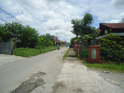
Berdasarkan hasil survey lapangan dapat dilihat bahwa pada lokasi tersebut tidak mempunyai saluran drainase yang tidak memadai.
Selain itu, kondisi ini diperparah dengan kondisi saluran yang terdapat semak belukar yang dapat mengganggu sirkulasi air.
sehingga jika terjadi hujan ringan menyebabkan terjadi banjir genangan.

ANALISIS
Analisis data dilakukan dengan menggunakan software QGIS dan InaSAFE.
Analisis dengan QGIS digunakan untuk mengedit perkiraan daerah yang terdampak oleh bencana dalam hal ini bencana banjir.
Sedangkan InaSAFE berguna dalam estimasi jumlah sarana dan prasarana area terdampak seperti bangunan.
Untuk Data hazard diperoleh dengan membuat area dengan poligon untuk landaan banjir,
kemudian daerah tersebut ditandai sebagai daerah rawan banjir.
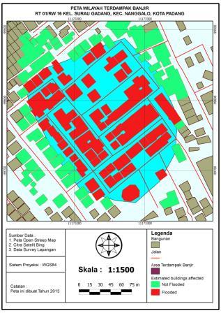
Berikut ini adalah hasil pemodelan dan perkiraan dampak dengan InaSAFE.
Skenario : Banjir genangan

Dari 167 bangunan, terdapat 94 bangunan yang terdampak (ditandai dengan warna merah pada peta).
Sedangkan 73 bangunan lainnya tidak terdampak (ditandai dengan warna hijau pada peta).
Missing file information
Hello! And thanks for your upload - but some extra info is necessary.
Sorry for bothering you about this, but it is important to know source of the uploaded files.
Are you the creator of image File:Peta Wilayah Terdampak Banjir 1.jpeg ?
Or is it copied from some other place (which one?)?
Please, add this info to the file page - something like "I took this photo" or "downloaded from -website link-" or "I took this screeshot of program XYZ" or "this is map generated from OpenStreetMap data and SRTM data" or "map generated from OSM data and only OSM data" or "This is my work based on file -link-to-page-with-that-file-and-its-licensing-info-" or "used file downloaded from internet to create it, no idea which one".
Doing this would be already very useful.
Licensing - photos
In case that you are the author of the image: Would you agree to open licensing of this image, allowing its use by anyone (similarly to your OSM edits)?
In case where it is a photo you have taken then you can make it available under a specific free license (except some cases, like photos of modern sculptures in coutries without freedom of panorama or taking photo of copyrighted artwork).
Would you be OK with CC0 (it allows use without attribution or any other requirement)?
Or do you prefer to require attribution and some other things using CC-BY-SA-4.0?
If you are the author: Please add {{CC0-self}} to the file page to publish the image under CC0 license.
You can also use {{CC-BY-SA-4.0-self|Bayubudi i}} to publish under CC-BY-SA-4.0 license.
Once you add missing data - please remove {{Unknown|subcategory=uploader notified 2022, August}} from the file page.
Licensing - other images
If it is not a photo situation gets a bit more complicated.
See Drafts/Media file license chart that may help.
note: if you took screenshot of program made by someone else, screenshot of OSM editor with aerial imagery: then licensing of that elements also matter and you are not a sole author.
note: If you downloaded image made by someone else then you are NOT the author.
Note that in cases where photo is a screenshot of some software interface: usually it is needed to handle also copyright of software itself.
Note that in cases where aerial imagery is present: also licensing of an aerial imagery matter.
Help
Feel free to ask for help if you need it - you can do it for example by asking on Talk:Wiki: new topic.
Please ask there if you are not sure what is the proper next step. Especially when you are uploading files that are not your own work or are derivative work (screenshots, composition of images, using aerial imagery etc).
If you are interested in wider discussion about handling licencing at OSM Wiki, see this thread.
(sorry if I missed something that already states license and source: I am looking through over 20 000 files and fixing obvious cases on my own, in other I ask people who upladed files, but it is possible that I missed something - in such case also please answer)
--Mateusz Konieczny (talk) 19:01, 25 August 2022 (UTC)