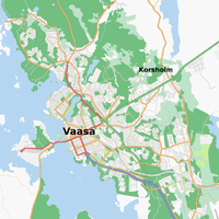
Vaasa
Jump to navigation
Jump to search
| V・T・E |
| latitude: 63, longitude: 21.8 |
| Browse map of Vaasa 63°00′00.00″ N, 21°48′00.00″ E |
| Edit map |

|
|
External links:
|
| Use this template for your locality |
Vaasa is a city in Finland at latitude 63°00′00.00″ North, longitude 21°48′00.00″ East.
Progress
(In August 2008)
Streets mostly mapped
- The city center (some block service roads (palokujat) missing as well as amenities etc.)
- Palosaari
- Isolahti
- Vetokannas
- Klemettilä (under the city's urban planning process - new streets and retail areas to come during the next few years)
- Korkeamäki
- Suvilahti
- Pukinjärvi
- Kotiranta
- Metsäkallio
- Kivihaka (a developing area, new streets and retail areas coming soon)
- Asevelikylä
- Vaskiluoto
- Kiilapalsta
- Huutoniemi
- Gerby (some cycleways missing)
- Västervik
- Melaniemi
- Purola
- Vanha Vaasa
- Teeriniemi (some streets missing)
Still things to do
- Ristinummi (a lot of cycleways missing)
- Runsor (some streets missing)
- Sundom (only main roads mapped)
- Sepänkylä in Mustasaari municipality (some residential streets mapped and most of them are lacking street names)
- A lot of cycleways missing, many parks unmapped, cemeteries, landuse, ..
- The address numbers of buildings?