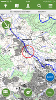
ViewRanger GPS
If you know about the current state of affairs, please help keep everyone informed by updating this information. (Discussion)
| ViewRanger GPS | |
|---|---|
| Author: | ViewRanger |
| License: | Proprietary (free (purchases available)) |
| Platforms: | Symbian, Android, iOS, BlackBerry OS, and Kindle |
| Status: | Broken |
| Version: | 10.11.72 (2022-01-30) |
| Languages: | English and German |
| Website: | http://www.viewranger.com/ |
| Install: | |
|
proprietary outdoors-oriented map app for mobile phones, OSM & cycle & piste maps | |
ViewRanger GPS (viewranger.com) is a proprietary outdoors-oriented GPS application for Symbian, Android and iOS. The software is developed by Augmentra Ltd, based in Cambridge, United Kingdom. Topo maps can be bought.
Requirements
Symbian, Android or iOS (links go to the main app stores).
Features
(this list at least applies to the Symbian version. Check the other app version descriptions for details. All versions seem to be similar, though.)
- online maps (bitmap tiles) display (cached). Freely configurable.
- OSM maps
- Microsoft satellite imagery
- offline (topo) maps can be bought (some free) in some regions
- track recording (it is possible to specify a maximum DOP value at until which the GPS position will be used and recorded; distance and time spacing between track points) and display
- POI recording and display
- gpx import/export
- route navigation (no routing)
- several configurable info screens (odometer, speed, gps reception, altitude, ...)
- journey graph view
- ...
Map configuration
(For advanced users only!) At least with the Symbian version you can freely configure the set of online maps which can be displayed. E.g. the maximum zoom level of OSM.org's mapnik layer can be increased to 18 which helps if you are surveying (to contribute to the OSM data) details. Level 17 is default. Level 19 (and over) crashes the app on viewing of this detail level.
The file xxx/ViewRanger/Config/glcfg.xml controls the set of maps. If you are somewhat XML-aware you can edit it (close the app during editing) using a simple text editor (preferably on a PC). The file contains the tile server names, min and max zoom levels, ….
Backup the original version of the file. Also save a backup of your edited version (preferably also on the mobile device under a different name) since ViewRanger overwrites that file when you select (could happen accidentally) "update sources" in menu "map sources".
Please use this config option wisely and at your own risk. Obey the service restrictions of the used tile providers (e.g. OSM.org's tile usage policy for the OSM "direct" tiles or CloudMade's for ViewRanger's default OSM tiles).
Installers
- v?.?.? (SIS) for S60 2nd edition phones
- v2.9.5 (SISX) for S60 3rd edition phones
- v2.9.5 (SISX) for S60 5th edition, ^3, Anna or Belle touch screen phones
- v6.x.x (APK) for Android
- v7.x.x-v10.x.x (APK) for Android
Links
- ViewRanger User Manual for Symbian (PDF)
- ViewRanger Wiki: Symbian platform
- ViewRanger Wiki: Android platform
- https://www.protrek.eu/r_global/pdf/UsersGuide_ViewRanger.pdf
- https://www.theramblers.ie/wp-content/uploads/2016/01/GPXLib-Viewranger-for-Android-a-quick-start-guide.pdf
- https://bugwoodcloud.org/pamf/resources/Viewranger_app_guide.pdf
- http://www.retrievatracking.com/myretrieva/docs/english/viewrangeruserinstructions.pdf
- http://www.sasgis.org/mantis/view.php?id=2866
- https://my.viewranger.com/oa-welcome
