WikiProject Haiti/New Mapper
- WikiProject revisions: Revisions to front page of WikiProject completed = everything consolidated into a single table or moved to different pages. --Ceyockey 16:34, 30 October 2011 (UTC)
- WikiProject revisions: Revisions are underway (slowly) to revise the WikiProject from crisis-response to mapping-as-usual mode. --Ceyockey 16:34, 30 October 2011 (UTC)
- On-the-ground: Fourth deploy write-up - 2010-09-08
- On-the-ground: HOT Mission 3 complete [1] - 2010-06-28
- Hot website launched with blog category 'Haiti' - 2010-05-??
There are various ways to help with the OpenStreetMap Effort in Haiti.
Marking Roads
The easiest way to help is to digitize roads. Most of the dense areas around Port-au-Prince have been covered, but there are portions of the country side still remaining.
Here is 3 minute video on how to get started specifically in Haiti.
Tagging Street Names
Sub-project Tagging Street Names using public domain maps
Marking Refugee Campsites
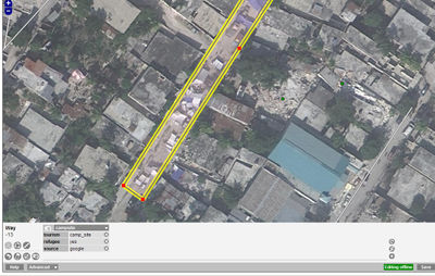
With extremely detailed imagery of Port-au-Prince one way you can help is by finding refugee campsites and marking them.
With the higher resolution imagery campsites such as this one can be identified:
Further Resources
Take the time to learn how our editing systems work. Here are some guides to help you.
- Beginners' guide to OpenStreetMap in general
- Potlatch/Primer - Guide to the flash editor "Potlatch" which appears on the Edit tab.
- JOSM/Guide - Guide to the Java OpenStreetMap editor, a desktop app.
- Map Features - List of tags to apply to different features on the map
- Look at the osm-matrix and see where you can find white areas.
Get instant help in our IRC chatroom. The main email list is talk. A dedicated list for new mappers is newbies.
Use the JOSM presets for the Haiti Earthquake Response in JOSM.
