Community Updates/2011-04-04
Community Update from 04 April 2011 to 10 April 2011 (week 2011-14)
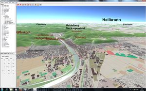
Image Of the Week 2011-14OSM-3D is now available for all of Europe as virtual globe (pictures, videos) |
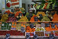
Project Of The Week : Grocery stores and supermarkets
Grocery stores sell fresh fruit and vegetables. A greengrocer might only sell fruit and vegetables, while a supermarket might also include other food ingredients like grains, meat and fish and processed foods.
The Project of the Month is to map your local sources of fresh fruit and vegetables.
Quick News
- http://openwhatevermap.xyz/ An April Fool joke with mixed OSM rendering
- MapQuest Critical Addresses File Updates https://lists.openstreetmap.org/pipermail/talk/2011-April/057492.html
- OSM Sub Redit
- City of Rostock is the first German city with completed housenumbers [1]
Events
- Crisis Mapping at TED http://www.ted.com/tedx/events/2496
Software
- New release of Vespucci 0.7 (an OSM editor for Android devices)
- New release of GpsMid 0.7.2 (you can try it with http://www.microemu.org on your desktop PC!)
Other News
Street blocks or street names?
Sometimes when you describe a place you talk about a block of building between 2 streets instead of the usual street name / house number.
Mike Frumin has put together a neat service that generates human-readable names based on nearby OSM ways:
Spanish Cadastre is available for OSM
Like in France and maybe other countries, the Spanish community has just obtained the right to use the "catastro" in OpenStreetMap. This announcement has the same impact as the one from the French Cadastre or Ordinance Survey permissions, maybe even better, as they have directly permission to get and use the vectorial data, updated every 3 months.
Another Great Release of MapQuest
Once again, MapQuest has released 3 awesome services to help the OSM community:
- A XAPI server : used to query the OSM db to fetch ie. every bike shop in a bounding box.
- A Pre-indexed Nominatim diff system. Its basically a "minutely mapnik" system for Nominatim so you can host yourself a Nominatim.
- A broken polygon detector. Nominatim outputs the broken polygons to a list with messages as to what was wrong.
Add Tag, a new Tool for collaboration between Wikipedia and OSM
Despite the possibility to add a Wikipedia article to an OSM object and to link an article to a point in OSM, there is not much collaboration between these 2 projects. The "Add Tag" tool tries to add a maximum of Wikipedia tags to OSM through the "remote control" protocol.
Draft / Voting : Parking Redux
The proposal was made some times ago. It proposes to add more micro-mapping friendly tags for parking like individual parking spaces,...
The proposal is now close to the voting phase, so please add your comments or if it's too late your vote.
Thanks
Big thanks to AndiPersti, Stephan75, Sanderd17 and !i! !

