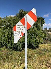
Tag:marker=paddle
| Description |
|---|
| A rhombus-shaped natural gas marker posted in an agricultural or natural area |
| Group: man made |
| Used on these elements |
| Useful combination |
| Status: in use |
| Tools for this tag |
|
A paddle marker is a kind of utility marker consisting of a rhombus-shaped sign on a post. The paddle tips downward, pointing to the location of a buried pipeline. Paddle markers serve the same purpose as composite markers (marker=post) but are installed in agricultural and natural areas to increase visibility amid crops and brush.
Where to find it
Paddle markers are known to be installed by the following American public utilities in their respective service areas:
| Public utility | Location | Substance | Colors |
|---|---|---|---|
| Kinder Morgan | Oregon | Petroleum | Black, yellow |
| Pacific Gas and Electric Company | Northern California | Natural gas | Orange, white |
| Sacramento Municipal Utility District | Sacramento, California | Natural gas | Red, yellow [1] |
PG&E's paddle markers are mounted on 10-foot-tall (3.0 m) posts. Occasionally, two paddles are mounted on a single post. [2][3] Pressure sensitive pipeline warning stickers in English and Spanish are affixed to the paddle, indicating the pipeline operator and phone numbers to call for more information or for emergencies. Typically, the paddle points directly to the pipeline, but a sticker affixed to it may indicate a lateral offset.
Examples
Pipelines
| Photo | Location | Tagging | Note |
|---|---|---|---|
| USA | utility=gas colour=orange;white material=metal operator=Pacific Gas and Electric Company operator:wikidata=Q1815011 |
A paddle indicating the presence of a natural gas pipeline buried below. |
See also
External links
- Gas Pipeline Markers in Agricultural Areas – Pacific Gas and Electric Company

