Tag:natural=mud
Jump to navigation
Jump to search
| Description |
|---|
| Area covered with mud: water saturated fine grained soil without significant plant growth. |
| Rendering in OSM Carto |

|
| Group: natural |
| Used on these elements |
| See also |
| Status: in use |
| Tools for this tag |
|
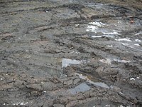
An area covered with mud, that is wet, water saturated fine grained soil without significant plant growth.
This tag should not be used for areas with intermittent water cover which are water covered or completely dry most of the time. Only use where wet mud is the most common state of the surface.
Since areas of mud are a type of wetland it is usually preferable to tag them natural=wetland with a supplemental tag (like wetland=tidalflat or wetland=mud - depending if the water is salted or not).
How to map
Draw an area ![]() around the grounds of the mud and add natural=mud.
around the grounds of the mud and add natural=mud.
See also
- natural=wetland + wetland=mud - Alternative tagging scheme
- natural=wetland + wetland=tidalflat - for tidal mud flats
- surface=mud - used for example on highways
- natural=dry_lake – for dry lakes and salt flats
| ||||||||||||||||||||||||||||||||
