User:Hofoen
Jump to navigation
Jump to search
| About Me | |||||||||||||||
|---|---|---|---|---|---|---|---|---|---|---|---|---|---|---|---|
| |||||||||||||||
Special:PrefixIndex/User:Hofoen
Current
- https://github.com/mapillary/OpenSfM
- Blattschnittgrenzen TK25 http://www.netzwolf.info/kartografie/openlayers/tkgrid.htm
- http://forum.openstreetmap.org/viewtopic.php?pid=364861#p364861
- Python + Geo http://www.carsonfarmer.com/2013/07/essential-python-geo-libraries/
- Verkehrszeichen: http://osmtools.de/traffic_signs/
- OSM JS OL http://http://tracks.osmsurround.org/ , misterboo
- WikiProject_Germany/Landesstraßen/Niedersachsen
- WikiProject_Germany/Bundesstraßen
- Street_area
- http://forum.openstreetmap.org/viewtopic.php?pid=264582#p264582
- http://lists.openstreetmap.org/pipermail/osmf-talk/2012-August/thread.html#
- http://mvexel.dev.openstreetmap.org/bing/
Sichten
- http://veloviewer.com/roads#map=14/52.388780637516064/9.692633781663794
- http://www.nypl.org/blog/2014/03/28/open-access-maps
Railway
- historic
* http://nrwbahnarchiv.bplaced.net/han/HBBG.htm
* http://www.bahnlatschen.de/
Who has Done What Where
- http://hdyc.neis-one.org/?hofoen
- http://yosmhm.neis-one.org/
- http://resultmaps.neis-one.org/oooc?zoom=11&lat=52.33369&lon=9.73694&layers=B00TFFFFFT
Short Cuts
- http://simon04.dev.openstreetmap.org/whodidit/?zoom=14&lat=52.38416&lon=9.749&layers=BTT&age=1000
- http://www.openstreetbrowser.org/
- DE:Howto_Map_A
Sortiert
Overpass
Cemetery
[out:json][timeout:25];
(
  node
  ["amenity"="grave_yard"]
  ["FIXME"!="exact position needed"]
  ["FIXME"!="field survey needed"]({{bbox}});
);
out body;
>;
out skel qt;
<source lang="perl">
[date:"2014-03-18T01:00:00Z"];

(
  area["name"="Puerto Tejada"];
  relation[boundary=administrative][admin_level=6](area);
  >;
);

out meta;
Boundary-Relationen innerhalb Area
area[name="Cabo Verde"] -> .a;

relation(area.a)[boundary=administrative] -> .x1;
.x1 >> -> .x2;
rel(bw.x2) -> .x3;

.x3 out meta;
Boundary-Relationen innerhalb Area
area[name="Namibia"];

way(area)[boundary=administrative];

<<;
out meta;
Boundary-Relationen innerhalb Area
area[name="Ísland"];

relation(area)[boundary=administrative];

out meta;
Ways ohne Relation
area[name="Niedersachsen"];

way(area)[boundary=administrative]->.alle;

// Selektiere alle Relationen, die einen dieser Ways als Member haben,
// dann wieder alle deren Way-Mitglieder
rel(bw.alle)[boundary=administrative];
way(r);

// Bilde aus beiden Mengen die Differenz
( .alle; - ._; );

// Visualisieren
(._;>;);
out meta;
xxx
[bbox:{{bbox}}];
(way[boundary="administrative"]);
(._;>;<<;);
out body;
Recht
- http://www.recht-niedersachsen.de/79100/nwaldlg.htm#p23
- http://www.recht-niedersachsen.de/7920002/njagdg.htm $ 2.1
Signs / Schilder
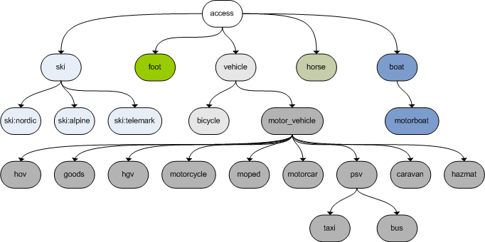
Access
- Computing_access_restrictions
- Key:access / DE:Key:access
- OSM_tags_for_routing/Access-Restrictions
- DE:Germany_roads_tagging
- Access-Restrictions#Germany

Tools
History
- http://nrenner.github.io/achavi/
- http://tyrasd.github.io/latest-changes/#17/52.24693/9.50976
- http://osmhistory.appspot.com/
- http://osmhv.openstreetmap.de/
- Quality_assurance#Monitoring_Tools
- http://osm.mapki.com/history/
- http://osmlab.github.io/osm-deep-history/
- http://zverik.osm.rambler.ru/whodidit/
- http://owl.apis.dev.openstreetmap.org/
QA
Comparison
Garmin Maps
- teddy http://wiki.openstreetmap.org/wiki/User:Computerteddy#Downloads_-_Kartendaten_f.C3.BCr_GPS-Ger.C3.A4te_von_Garmin
- http://www.easyclasspage.de/karten/
- http://www.kleineisel.de/blogs/index.php/osmmap/
mkgmap
- http://noegs.blogspot.de/2012/01/tracks-als-transparente-garmin-karte.html
- http://www.javawa.nl/imgfromgpx_en.html
Special Maps
Temporal Mapping
- https://lists.openstreetmap.org/listinfo/historic
- http://wiki.openstreetmap.org/wiki/Historical_OSM
- http://wiki.openstreetmap.org/wiki/OSM-4D
- https://wikidata-todo.toolforge.org/tempo_spatial_display.html?q=Q46083&title=The%20Franco-Prussian%20War&subtitle=Major%20battles
Unsorted
- Various
- Hiking