Cambridgeshire
| V・T・E |
| latitude: 52.16495246227759, longitude: 0.09886949550951424 |
| Browse map of Cambridgeshire 52°09′53.83″ N, 0°05′55.93″ E |
| Edit map |
|
External links:
|
| Use this template for your locality |
Cambridgeshire is a county in East of England, England at latitude 52°09′53.83″ North, longitude 0°05′55.93″ East.
Cambridgeshire relicensing problems
The ceremonial county of Cambridgeshire 87521![]() 87521, in the East of England region, is made up of the non-metropolitan county of Cambridgeshire 180837
87521, in the East of England region, is made up of the non-metropolitan county of Cambridgeshire 180837![]() 180837 together with the unitary authority of Peterborough. The ceremonial county of Cambridgeshire borders with Bedfordshire, Essex, Hertfordshire, Northamptonshire and Suffolk.
180837 together with the unitary authority of Peterborough. The ceremonial county of Cambridgeshire borders with Bedfordshire, Essex, Hertfordshire, Northamptonshire and Suffolk.
Progress
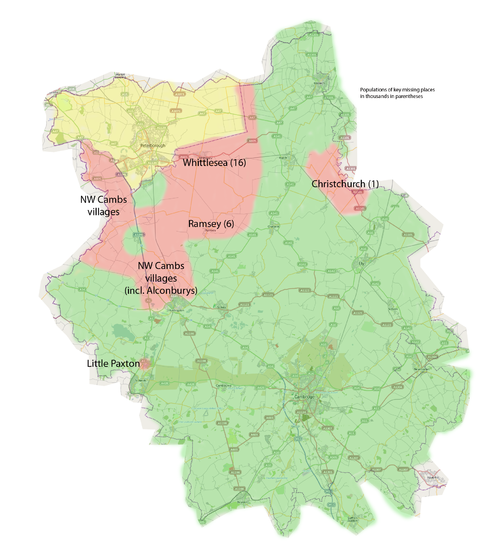
We are trying to complete Cambridgeshire by mid 2010. Progress is excellent so far, with some of the major gaps in the NE (Wisbech and environs), Chatteris and Manea having been filled recently. The largest outstanding settlement at March 2010 is Whittlesea (16,000) which will hopefully be done systematically in April, followed by Ramsey (8,000). The remainder are all small viullages, mostly in the NW of the county near Peterborough (which isn't part of Cambridgeshire BTW).
Status as at March 2010. (Note: Alconbury and Little Paxton might look as if they are done, but there are definitely significant parts missing, so they don't appear to have been done systematically.
Districts in Cambridgeshire
The non-metropolitain county of Cambridgeshire is divided into five districts:
| Number complete | |||||
|---|---|---|---|---|---|
| Area | Cities | Towns | Villages | Notes | Boundary Relation |
| Cambridge [1] | 295355 | ||||
| East Cambridgeshire [2] | 295352 | ||||
| Fenland [3] | 295349 | ||||
| Huntingdonshire [4] | 295351 | ||||
| South Cambridgeshire [5] | 295353 | ||||
Settlements in Cambridgeshire
This is a list of the settlements in the ceremonial county of Cambridgeshire with a population over 5,000.
Taken from the wikipedia article: Cambridgeshire - Settlements

