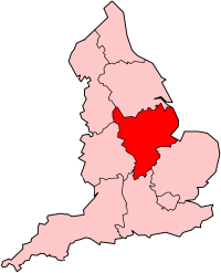
East Midlands
| V・T・E |
| latitude: 53.209, longitude: -0.441 |
| Browse map of East Midlands 53°12′32.40″ N, 0°26′27.60″ W |
| Edit map |
|
External links:
|
| Use this template for your locality |
East Midlands is a region in England, United Kingdom at latitude 53°12′32.40″ North, longitude 0°26′27.60″ West.

|
The East Midlands region (151279![]() 151279) consists of Derbyshire, Nottinghamshire, Leicestershire, Rutland, Northamptonshire and most of Lincolnshire.
151279) consists of Derbyshire, Nottinghamshire, Leicestershire, Rutland, Northamptonshire and most of Lincolnshire.
East Midland OSM Mappers
Mappers from parts of the East Midlands and S Yorkshire meet monthly for a social event which prior to Covid rotatesd round Nottingham, Derby & Sheffield. It also (deliberately) provides a format for people who just want to learn a bit more about OSM:
* During summer months (April to September) we usually schedule a 1 hour of mapping beforehand. This is deliberately meant to be a suitable introduction as to how to map things, and usually involve checking for changes in city centre shops. If you want to learn more about OSM, or about which tools experienced mappers use, this can be a good primer.
Normally the first part of the meeting in the pub will focus on specific OSM mapping issues or news, before it transforms into more social chit chat. We have regular attendees experienced in mapping public rights of way, cycling infrastructure, addresses, humanitarian mapping, and a range of other topics. We also have members familiar with the underlying cartography of OSM and how to set-up the OSM software stack. People are very welcome to drop by to come and ask specific questions on any of these topics.
During Covid times the meeting may either be held on-line (using BigBlueButton) or is located at The Brunswick, Railway Terrace, Derby. For details of the next meeting it is best to consult OSM Calendar, and if I remember to update it this wiki page
The meeting is held on the 3rd or 4th Tuesday of each month (normally the one closest to 21st). We also hold occasional day-long events mapping public rights of way. We try & hold at least one a year around New Year's Day in a location which is within 1 hr drive or thereabouts of population centres in both East & West Midlands.
